Risk Modeler AIR Worldwide Updates US Hurricane, Inland Flood Model

July 23, 2020

Catastrophe risk modeling firm AIR Worldwide (AIR) has updated its hurricane and inland flood models for the United States.
The update for the hurricane model includes a new module for precipitation-induced flood risk, while the flood model includes enhancements to both hazard and vulnerability, including a higher resolution digital terrain model, AIR said.
The updates will help insurers and reinsurers enhance their risk management and provide a comprehensive view of flood risk across the US and across all property lines of business, the risk modeler said.
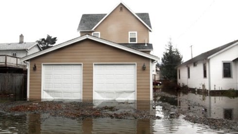
AIR noted that the 2017 and 2018 Atlantic hurricane seasons set records for precipitation and included severe flooding brought on by intense storms. In addition to nontropical extreme precipitation events, stalling tropical systems have increased in frequency and severity over the past century, AIR said. Examples include Hurricane Harvey flooding Texas in 2017 with record-breaking rainfall, and 2018's Hurricane Florence causing severe flooding in the Carolinas.
AIR's updated inland flood model incorporates a physically-based two-dimensional shallow water wave model to simulate off-plain flood risk over the contiguous US, AIR said. The risk modeler said that by more accurately modeling all surface water flooding during an event, modeling both the flow from rivers onto land and the flooding over areas away from rivers, the updated inland flood model provides a complete view of US inland flood risk, both on and off floodplains.
The model leverages several loss data sets for model loss validation, AIR said. Nearly $70 billion of actual National Flood Insurance Program loss data, taken from 1978 through 2018, were used in validating the model. To evaluate nonresidential losses, the model relies on more than a decade of private market insured loss data, AIR said.
July 23, 2020