NOAA Assesses US Climate Disaster Events in 2019

January 20, 2020

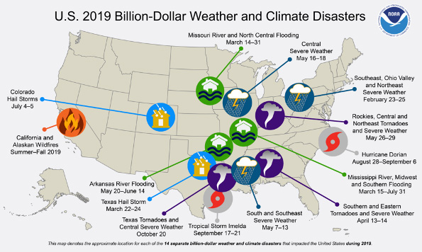
According to the National Oceanic and Atmospheric Administration (NOAA), in 2019, there were 14 weather and climate disaster events with losses exceeding $1 billion each across the United States: three inland flooding events, eight severe storm events, two tropical cyclone events (Dorian and Imelda), and one wildfire event. An above-average year of costs ($45.0 billion) was experienced in 2019, as the 40-year (1980–2019) annual cost average is $43.9 billion (inflation adjusted). The combined cost of the Missouri, Arkansas, and Mississippi river flooding ($20.0 billion) was almost half of the US total cost in 2019. There was a trend of an increasing number of billion-dollar inland flooding events during the 2010s.
- The total cost of US billion-dollar disasters over the last 5 years (2015–2019) exceeds $525 billion, with a 5-year annual cost average of $106.3 billion (Consumer Price Index adjusted), both of which are records.
- The US billion-dollar disaster damage costs over the last decade (2010–2019) were also historically large—exceeding $800 billion from 119 separate billion-dollar events.
- Even after adjusting for inflation, the United States experienced more than twice the number of billion-dollar disasters during the 2010s (119) when compared to the 2000s (59).

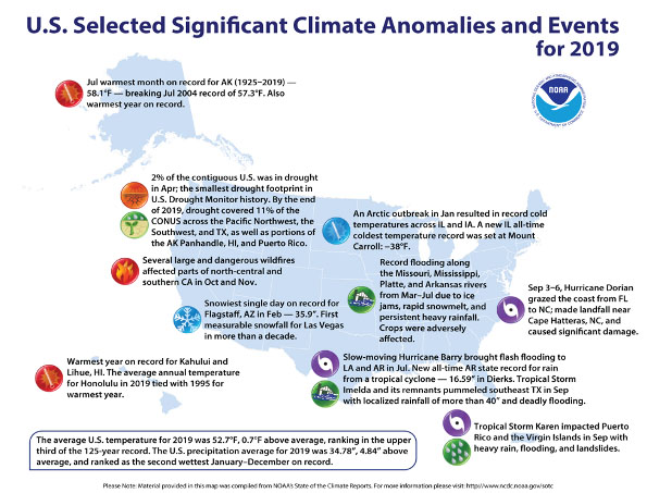
- During mid-March, a "bomb cyclone" developed in the central United States, bringing snow, blizzard conditions, heavy rainfall, and above-freezing temperatures across parts of the interior United States, which already had significant snowpack on the ground from the winter of 2018–2019. This resulted in widespread flash flooding due to the combination of new rainfall, rapidly melting snow, and frozen ground. A state of emergency was declared for parts of Nebraska, Iowa, South Dakota, and Wisconsin as the Missouri, Platte, and Mississippi Rivers breached their banks. Flooding continued well into July along the Missouri, Mississippi, Platte, and Arkansas Rivers due to ongoing heavy rainfall. Many crops were adversely impacted by these wet conditions during 2019.
- Several large-scale flooding events impacted the nation during 2019, including the rainfall associated with Tropical Storm Imelda in September across southeast Texas and southwestern Louisiana. More than 40 inches of rain fell in Jefferson County, Texas, over a 5-day period. Slow-moving Hurricane Barry brought flash flooding to Louisiana and Arkansas in July. Dierks, Arkansas, reported 16.59 inches of rainfall, which is a new record for rain from a tropical cyclone across the state.
- Hurricane Dorian made landfall at Hatteras, North Carolina, on September 6 as a Category 1 hurricane with maximum sustained winds estimated near 90 mph. The storm grazed the East Coast from central Florida to the Outer Banks and continued on a path that eventually made landfall in Nova Scotia with 100 mph sustained winds. Earlier in the month, Dorian slammed the Bahamas with Category 5 winds. Dorian's 185-mph landfalling wind speed in the Bahamas ties with the Labor Day hurricane of 1935 as the strongest landfalling Atlantic hurricane on record.
- Several large and dangerous wildfires impacted parts of north-central and Southern California during October and November. The Kincade Fire, located in Sonoma County, California, burned through nearly 78,000 acres and destroyed approximately 350 structures. The Tick, Saddle Ridge, and Getty Fires in Southern California consumed more than 14,000 acres as well as 60 structures. The Easy Fire, also located in Southern California, consumed more than 1,800 acres by the beginning of November. These large and dangerous fires were fanned by powerful winds, with some gusts topping 100 mph in the Sierra Nevada range. Across Southern California, unusually strong Santa Ana winds made it difficult for fire crews to keep these fires from spreading. For 2019, wildfire activity across the United States was below average with 4.6 million acres consumed—the sixth-lowest area consumed and the second-fewest number of fires in the last 20 years. Wildfires across Alaska consumed 2.68 million acres in 2019, ranking sixth highest in the past 50 years.
- The 2019 hurricane season was above normal, particularly in terms of the number of named storms (18 with winds ≥ 39 mph) and accumulated cyclone energy (ACE) about 25 percent above the 1981–2010 mean. Many of the storms were weak, short-lived, and higher-latitude than normal: only 8 of the 18 storms lasted more than 72 hours, and 7 of them lasted 24 hours or less. Meanwhile, the two Category 5 storms (Dorian and Lorenzo) were each exceptionally long-lived. These two storms accounted for more than 60 percent of 2019's ACE, or about 75 percent of the ACE observed in an average season. Dorian's winds were among the strongest of any Atlantic hurricane in history before it made landfall in the Bahamas as a Category 5 storm and stalled for more than 24 hours. Lorenzo, on the other hand, was noteworthy for being the farthest east Category 5 storm in history.
- The Northern Tier of the United States received above-average snowfall during the 2018–2019 snow season. In Caribou, Maine, it was the snowiest January on record (59.8 inches). Caribou also broke another record for the most consecutive days with at least 1 inch of snow on the ground (163 days from November 10, 2018, to April 21, 2019). Record snowfall and cold temperatures occurred from Washington State to Wisconsin in February with Eau Claire, Wisconsin, reporting its all-time snowiest month (53.7 inches).
- Over 1,500 tornadoes were reported in 2019, making it a top-five year across the contiguous United States. The most active day in 2019 for tornadoes was May 27 with over 77 confirmed tornadoes from Colorado to Ohio. There were 70 confirmed tornadoes during a March 3 outbreak across Alabama, Georgia, and South Carolina. March 3 was also the deadliest day in 2019 for tornadoes with 23 fatalities in Alabama from one EF-4 tornado. There were no EF-5 tornadoes reported during 2019.
- The US Climate Extremes Index (USCEI) for 2019 was 14 percent above average and ranked in the upper third of the 110-year record. Warm extremes across the Southeast, cold extremes in the central United States, and wet conditions throughout the year from the central United States to the East Coast contributed to this elevated USCEI value. The USCEI is an index that tracks extremes (falling in the upper or lower 10 percent of the record) in temperature, precipitation, drought, and landfalling tropical cyclones across the contiguous United States.

(Temperature and precipitation values and ranks are based on preliminary data. Additional data received and processed after the release of this summary may result in small differences for annual values and ranks.)
January 20, 2020


